 |
| Jhelum |
Online Earning Course in Jhelum. Earn 30,000+ Monthly.
. Course Fee 8000 Rs. (70$ Only) Complete Training course with 5 skillsGet Details Contact Us

NewJhelum.com خوش آمدید
تاریخ جہلم
=======================================
Jhelum History,Rohtas fort,Mangla Dam,Khewra Salt mines,Shahabbudin ghouri tomb,Jhelum River,. In this blog all history collected from different websites and books.You can check our dina history blog,Sohawa Histy and khewra Salt mines History and photos. Like our Jhelum city Page , Click Here to LIKE
جہلم
پاکستان میں صوبہ پنجاب کا ایک اہم شھر ہے۔ جہلم دریائے جہلم اور جی ٹی روڈ کے سنگم پر واقع ہے۔ دریا کے دوسرى طرف سرائے عالمگير نام کا قصبہ واقع ہے جہاں ملٹری کالج جہلم واقع ہے۔ جی ٹی روڈ ان دونوں آبادیوں سے گذرتا ہے۔ جہلم کی اھم مقامات میں تاریخی قلعہ رہتاس اور منگلہ ڈیم ہیں۔
یہاں ایک گالف کھیلنے کا میدان بھی ہے جہان قومی گالف تورنامنٹ منعقد ہوتے ہیں۔
جہلم کے لوگ فوج کی ملازمت کو ترجیح دیتے ہیں۔
یہاں ایک گالف کھیلنے کا میدان بھی ہے جہان قومی گالف تورنامنٹ منعقد ہوتے ہیں۔
جہلم کے لوگ فوج کی ملازمت کو ترجیح دیتے ہیں۔
جہلم برطانوی عہد میں
>
 |
| 1849 British |
 |
| St. John's Church Jhelum which was built in 1860 |
 |
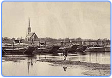
| Old Bridge Jhelum 1872 |
برطانوی دور میں جہلم میں وسیع پیمانے پر تبدیلیاں کیں گئی یہاں ایک بہت بڑی چھاونی تعمیر کی گئی۔
اس کے ساتھ ایک بہت بڑا ہسپتال بھی تھا۔
1872 میں تاریخی ریلوے پل دریاۓ جہلم پر بنایا گیا، مختلف گرجا گھر بناۓ گۓ۔
قیام پاکستان کے بعد
>

قیام پاکستان کے بعد شہر کی ہندو آبادی بھارت
چلی گئی اور مہاجرین ان کی جگہ آباد ہو گۓ۔

 |
| Major M.Akram Shaheed |
-------------------------------------------------------------------------------------------------
1992 میں دریاۓ جہلم میں آیا سیلاب بھی جہلم کے لوگوں کے لیۓ ایک المیہ تھا۔
 |
| Flood In Jhelum,1992 |
Jhelum Short History

آب و ہوا
گرمیوں میں جہلم کا درجہ حرارت سخت گرم ہوتا ہے۔ سالانہ بارش کی مقدار 35 انچ سالانہ ہے۔
رقبہ
جہلم کا رقبہ 3587 مربع کلومیٹر ہے -
ملک | پاکستان |
| صدر مقام | جہلم |
| صوبہ | پنجاب |
| محل وقوع | 32.94 درجے شمال، 73.72 درجے مشرق |
| رقبہ | 3587 مربع کلومیٹر |
| بلندی | 250 میٹر (820.21 فٹ) از سطحِ سمندر |
| آبادی | 9,69,957 بمطابق 1998ء |
| زبانیں | پنجابی، اردو |
| منطقۂ وقت | عالمی معیاری وقت + 5 |
| رمزِ ڈاک | 49600 |
| رمزِ بعید تکلم | 0544 |
| تحصیلیں | 4 |
 |
| Railway Bridge |
Jhelum Urdu History
دریائے جہلم اور سکندر اعظم
دریائے جہلم
دریائے جہلم کوہ ہمالیہ میں چشمہ ویری ناگ سے نکل کر سری نگر کی ڈل جھیل سے پانی لیتا ہوا پاکستان میں داخل ہوتا ہے اور جنوب مغرب کو بہتا ہوا تریموں کے مقام پر یہ دریائے چناب سے مل جاتا ہے۔یہ مغربی پنجاب کےدریاؤں میں سے اہم دریا ہے۔ یہ سارے دریا پنج ند کے قریب دریائے سندھ میں مل جاتے ہیں۔
رسول کے مقام پر دریائے سندھ سے نہر لوئر جہلم نکالی گئی ہے جو ضلع شاہ پور کو سیراب کرتی ہے۔ رسول کی پن بجلی کامنصوبہ اسی کا مرہون منت ہے۔ نہراپر جہلم منگلا ’’ آزاد کشمیر‘‘ کے مقام پر سے نکالی گئی ہے۔ اور ضلع گجرات کے بعض علاقوں کو سیراب کری ہے۔ آب پاشی کے علاوہ ریاست کشمیر میں عمارتی لکڑی کی برآمد کا سب سے بڑا اور آسان ذریعہ یہی دریا ہے۔ سکندر اعظم اور پورس کی لڑائی اسی دریا کے کنارے لڑی گئی تھی۔ سکندر اعظم نے اس فتح کی یادگار میں دریائے جہلم کے کنارے دو شہر آباد کیے۔ پہلا شہر بالکل اسی مقام پر تھا جہاں لڑائی ہوئی تھی۔ اور دوسرا دریا کے اس پار یونانی کیمپ میں بسایا گیا تھا۔ اس شہر کو سکندر اعظم نے اپنے محبوب گھوڑے بیوسیفاتس سے منسوب کیا جو اس لڑائی میں کام آیا تھا۔
__________________________________________________________
ضلع جہلم کی دیگر تحصیلیں
تحصیل جہلم
تحصیل جہلم ضلع جہلم، پنجاب، پاکستان کی چار تحصیلوں میں سے ایک تحصیل ہے۔[1] اس تحصیل کا صدر مقام جہلم ہے۔ اس میں 27 یونین کونسلیں ہیں۔
تحصیل پنڈ دادنخان
>
تحصیل پنڈ دادنخان ضلع جہلم، پنجاب، پاکستان کی چار تحصیلوں میں سے ایک تحصیل ہے۔[1] اس تحصیل کا صدر مقام پنڈ دادنخان ہے۔ اس میں 16 یونین کونسلیں ہیں۔
تحصیل دینہ
>
تحصیل دینہ ضلع جہلم، پنجاب، پاکستان کی چار تحصیلوں میں سے ایک تحصیل ہے۔[1] اس تحصیل کا صدر مقام دینہ ہے۔
تحصیل سوہاوہ
>
تحصیل سوہاوہ ضلع جہلم، پنجاب، پاکستان کی چار تحصیلوں میں سے ایک تحصیل ہے۔[1] اس تحصیل کا صدر مقام سوہاوہ ہے۔ اس میں 10 یونین کونسلیں ہیں۔
قلعہ روہتاس ----- History Rohtas Fort
 |
| Sher Shah Suri |
1 روایت
2 اخراجات
3 رقبہ
4 دروازے
5 فصیل
6 عمارات
6.1 شاہی مسجد
6.2 حویلی مان سنگھ
6.3 رانی محل
6.4 کنوئیں
6.5 تالاب
6.6 لنگر خان
6.7 پھانسی گھر
Rohtas Fort Urdu History,
6.7 پھانسی گھر
Rohtas Fort Urdu History,
Rohtas urdu history
Rohtas Fort ,history in english
Rohtas Fort in English History
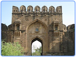
قلعہ روہتاس کا داخلی دروازہ
شیر شاہ سوری کا تعمیر کیا گیا قلعہ 948ھ میں مکمل ہوا ۔ جو پوٹھوہار اور کوہستان نمک کی سرزمین کے وسط میں تعمیر کیا گیا ہے۔ جس کے ایک طرف نالہ کس، دوسری طرف نالہ گھان تیسری طرف گہری کھائیاں اور گھنا جنگل ہے۔ یہ شیر شاہ سوری نے یہ قلعہ گکھڑوں کی سرکوبی کے لیے تعمیر کرایا تھا۔ دراصل گکھڑ مغلوں کو کمک اور بروقت امداد دیتے تھے، جو شیر شاہ سوری کو کسی طور گوارا نہیں تھا۔ جب یہ قلعہ کسی حد تک مکمل ہوگیا تو شیر شاہ سوری نے کہا کہ آج مین نے گکھڑوں کی پیٹھ میں چھرا گھونپ دیا ہے۔ اس قلعے کے عین سامنے شیر شاہ سوری کی بنائی ہوئی جرنیلی سڑک گزرتی تھی ، جو اب یہاں سے پانچ کلومیٹر دور جا چکی ہے۔
ہ
دوسرے قلعوں سے ہٹ کر قلعہ روہتاس کی تعمیر چھوٹی اینٹ کے بہ جائے دیوہیکل پتھروں سے کی گئی ہے۔ ان بڑے بڑے پتھروں کو بلندیوں پر نصب دیکھ کر عقل حیران رہ جاتی ہے۔ ایک روایت کے مطابق اس قلعے کی تعمیر میں عام مزدروں کے علاوہ بے شمار بزرگانِ دین نے اپنی جسمانی اور روحانی قوتوں سمیت حصہ لیا۔ ان روایات کو اس امر سے تقویت ملی ہے کہ قلعے کے ہر دروازے کے ساتھ کسی نہ کسی بزرگ کا مقبرہ موجود ہے ، جب کہ قلعے کے اندر بھی جگہ جگہ بزرگوں کے مقابر موجود ہے، جب کہ قلعے کے اندر بھی جگہ جگہ بزرگوں کے مقابر پھیلے ہوئے ہیں۔ اس کے علاوہ ایک اور روایات ہے کہ یہاں قلعے کی تعمیر سے پہلے ایک بہت بڑا جنگل تھا۔ شیر شاہ سوری کا جب یہاں گزر ہوا تو یہاں پر رہنے والے ایک فقیر نے شیر شاہ سوری کو یہاں قلعہ تعمیر کرنے کی ہدایت دی۔
اخراجات
ایک روایت کے مطابق ٹوڈرمل نے اس قلعے کی تعمیر شروع ہونے والے دن مزدروں کو فی سلیب (پتھر) ایک سرخ اشرفی بہ طور معاوضہ دینے کا اعلان کیا تھا۔ گو قلعہ کی تعمیر پر اٹھنے والے اخراجات کا درست اندازہ نہیں لگایا جاسکتا تاہم ایک روایت کے مطابق اس پر 34 لاکھ 25 ہزار روپے خرچ ہوئے ۔ واقعات جہانگیری کے مطابق یہ اخراجات ایک پتھر پر کندہ کیے گئے تھے جو ایک زمانے میں قلعے کی کسی دروازے پر نصب تھا۔ قلعے کی تعمیر میں 3 لاکھ مزدوروں بہ یک وقت حصہ لیا اور یہ 4 سال 7 ماہ اور 21 دن میں مکمل ہوا۔
[]رقبہ
یہ چار سو ایکٹر پر محیط ہے ، جب کہ بعض کتابوں میں اس کا قطر 4 کلومیٹر بیان کیا گیا ہے۔ قلعے کی فصیل کو ان جٹانوں کی مدد سے ترتیب و تشکیل دینے کی کوشش کی گئی جن پر یہ تعمیر کیا گیا۔ قلعہ اندرونی طور پر دو حصوں میں تقسیم تھا جس کے لیے 1750 فٹ طویل ایک دیوار تعمیر کی گئی، جو قلعے کے دفاعی حصے کو عام حصے سے جدا کرتی تھی۔ یہ ان قدیم روایتوں کا تسلسل تھا ، جن کے تحت فوجوں کی رہائش شہروں سے علیحدہ رکھی جاتی تھی۔ قلعے کی جنگی حصے کی وسعت کا اندازہ اس امر سے لگایا جاسکتا ہے کہ عہد شیر شاہ میں توپ خانے کے علاوہ 40 ہزار پیدل اور 30 ہزار سوار فوج مع ساز و سامان یہاں قیام کرتی تھی۔ قلعے میں 86 بڑے بڑے برج یا ٹاور تعمیر کیے گئے ۔ اور پانی کی فراہمی میں خود کفالت کے لیے تین باولیاں (سیڑھیوں والے کنویں( بنائی گئیں تھیں۔ ان میں سے ایک فوجی حصے میں اور باقی پانی کی پانچ ذخیرہ گاہوں سمیت قلعے کے دورے حصے میں واقع تھیں۔
[]دروازے
 |
| Rohtas Fort Door |
قلعے کے بارہ دروازے ہیں۔ جن کی تعمیر جنگی حکمت علمی کو مد نظر رکھ کر کی گئی ہے۔ یہ دروازے فن تعمیر کا نادر نمونہ ہیں ۔ ان دروازوں میں خواص دروازہ ، موری دروازہ ، شاہ چانن والی دروازہ ، طلاقی دروازہ ، شیشی دروازہ ، لنگر خوانی دروازہ ، بادشاہی دروازہ ، کٹیالی دروازہ ، سوہل دروازہ ، پیپل والا دروازہ ، اور گڈھے والا دروازہ، قلعے کے مختلف حصوں میں اس کے دروازوں کو بے حد اہمیت حاصل تھی۔ اور ہر دروازہ کا اپنا مقصد تھاجبکہ خاص وجہ تسمیہ بھی تھی۔ ہزار خوانی صدر دروازہ تھا۔ طلاقی دروازے سے دور شیر شاہی میں ہاتھی داخل ہوتے تھے۔ طلاقی دروازے کو منحوس دروازہ سمجھا جاتا تھا۔ شیشی دروازے کو شیشوں اور چمکتے ٹائلوں سے تیار کیا گیا تھا۔ لنگر خوانی لنگر کے لیے استعمال ہوتا تھا۔ کابلی دروازے کا رخ چونکہ کابل کی طرف تھا اس لیے اس کو کابلی دروازہ کہا جاتا تھا۔سوہل دروازہ زحل کی وجہ سے سوہل کہلایا۔ جبکہ اس کو سہیل دروازہ بھی کہا جاتا تھا کیونکہ حضرت سہیل غازی کا مزار یہیں واقع تھا۔گٹیالی دروازے کا رخ چونکہ گٹیال پتن کی طرف تھا اس لیے اس کو یہی نام دیا گیا۔ اس طرح مختلف دروازوں کے مقاصد مختلف تھے اور ان کو مختلف کاموں کے لیے استعمال کیا جاتا تھا۔ بارہ دروازوں میں سے ایک یعنی لنگر خوانی دروازہ براہ راست جنگی علاقے میں کھلتا تھا اور یہ دشمن کی فوجوں کے لیے ایک طرف کا جال تھا۔ اس دروازے سے گزر کر اندر آنے والا شخص فیصل کی برجیوں پر مامور محافظوں کے براہ راست نشانے پر آ جاتا تھا۔ اس طرح خواص خوانی دروازہ دہرا بنایا گیا تھا۔ مغربی سمت ایک چھوٹی سی ’’ریاست‘‘ علیحدہ بنائی گئی تھی جو چاروں جانب سے دفاعی حصار میں تھی۔ اس کے اندر جانے کا صرف ایک دروازہ تھا ۔ اس چھوٹی سی ریاست کے بلند ترین مقام پر راجا مان سنگھ کی حویلی تھی جو مغل شہنشاہ اکبر اعظم کا سسر اور اس کی فوج کا جرنیل تھا۔
[]فصیل
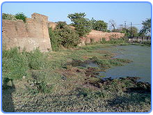
قلعہ روہتاس کا سب سے قابلِ دید ، عالی شاہ اور ناقابل شکست حصہ اس کی فصیل ہے۔ اس پر 68 برج ، 184 برجیاں ، 06881 کگرے اور 8556 سیڑھیاں ہیں جو فن تعمیر کا نادر نمونہ ہیں۔ اس کے برج صرف فصیل کی خوب صورتی ہی میں اضافہ نہیں کرتیں بلکہ یہ قلعے کے مضبوط ترین دفاعی حصار میں بھی اہم کردار ادا کرتے ہیں۔ فصیل کی جوڑائی سب سے زیادہ ہے۔ فصیل کے چبوترے سیڑھیوں کے ذریعے سے ایک دوسرے سے منسلک تھے۔ فصیل تین منزلوں میں دو یا سہ قطاری تعمیر کی گئی تھی۔ سب سے بلند ترین حصہ کنگروں کی صورت میں تعمیر کیا گیا۔ چبوتروں کی چوڑائی تین فٹ سے زیادہ ہے اور یہ تیر اندازوں اور توپچیوں کے لیے استعمال کیے جاتے تھے۔ ان کی بلندی مختلف تھی ، جو 8 فٹ سے 11 فٹ کے درمیان تھی۔ یہ کنگرے صرف شاہی فوجوں کو دشمن سے تحفظ ہی فراہم نہیں کرتے ھے بلکہ ان سے دشمنوں پر پگھلا ہوا سیسہ اور کھولتا ہوا پانی انڈیلا جاتا تھا۔ درمیانی چبوترے درحقیقت فوجیوں کے کھڑے ہونے کی جگہ تھی اور ان کی چوڑائی ساڑھے چار فٹ سے 7 فٹ کے درمیان تھی، جب کہ چبوتروں کی آخری قطار کی چوڑائی ساڑھے چھ فٹ سے سارٹھ آٹھ فٹ کے درمیان تھی۔
 |
| Rohtas Fort Jhelum |
[]عمارات
یہ بات حیرت انگزیز ہے کہ اتنے بڑے قلعے میں محض چند رہائشی عمارتیں تعمیر کی گئی ہیں۔ قلعے کی عمارتوں میں سے ایک عمارت کو شاہ مسجد کہا جاتا ہے اور چند باؤلیاں تھیں، بعد ازاں ایک حویلی تعمیر کی گئی ، جسے راجا مان سنگھ نے بنوایا تھا ۔ محلات کے نہ ہونے کے باعث مغل شہنشاہ اس قلعے میں آکر خمیوں میں رہا کرتے تھے ۔ یہ قلعہ صرف دفاعی حکمت علمی کے تحت بنایا گیا تھا ، اس لیے شیر شاہ سوری کے بعد بھی برسر اقتدار آنے والوں نے اپنے ٹھہرنے کے لیے یہاں کسی پرتعیش رہائش گاہ کا اہتمام نہیں کیا۔
[]شاہی مسجد
شاہی مسجد چھوٹی لیکن خوب صورت مسجد ہے۔ یہ مسجد کابلی دروازے کے نزدیک واقع ہے اور اسی وجہ سے کابلی دروازے کو بادشاہی دروازہ بھی کہا جاتا ہے۔ یہ مسجد صرف ایک کمرے اور صحن پر مشتمل ہے۔ مسجد کا مرکزی ہال 63 فٹ طویل اور 24 فٹ چوڑا ہے۔ اسے تین حصوں میں تقسیم کیا گیا ہے۔ مرکزی ہال کی اندرونی چھت مسطح ہے، البتہ اوپر گنبد بنے ہوئے ہیں۔ لیکن اس کے باہر کوئی کوئی مینار یا گنبد نہیں۔ بیرونی دفاعی دیوار اس کی پشت پر واقع ہے۔ یہ مسجد سوری عہد کی چند انمول اور قابل دید تعمیرات میں سے ایک ہے۔
[]حویلی مان سنگھ
حویلی مان سنگھ مغل شہنشاہ اکبر اعظم کے وفادار جرنیل راجہ مان سنگھ کے نام سے موسوم ہے ، جس کا انتقال 1614ء میں ہوا۔ یہ محل قلعہ روہتاس کی سب سے بلند ترین چٹان پر تعمیر ہوا اور اس کی طرز تعمیر کافی حد تک عربی ، ایرانی اور افغانی کے بجائے ہندوانہ تھا ۔ 25 بیگھا زمین پر سطح سمندر زمین سے 2260 فٹ کی بلندی پر تعمیر ہونے والا یہ محل سفید رنگ کا تھا۔
اکبر اعظم نے اس گنبد نما محل کو مزید خوب صورتی بخشنے کے لیے اس کے اردگرد مزید عمارات بھی تعمیر کرائی تھیں۔ اس کی چھتوں ، دروازوں اور جھروکوں وغیرہ میں آج تک نفیس نقش و نگار اور پچی کاری موجود ہے۔
[]رانی محل
رانی محل حویلی مان سنگھ سے تین سو گز کے فاصلے پر شمال کی جانب موجود ہے۔ اس میں راجا مان سنگھ کی بیوہ بہن شریمتی روپ کماری رہتی تھی ۔ یہ محل چونکہ اپنا اصل رنگ و روپ کھو چکا ہے اس لیے لوگ اب اسے کالا محل کہتے ہیں۔ اسے بھربھرے پتھر سے ایک مینار کی صورت میں بنایا گیا تھا جس کی بلندی 80 فٹ ہے۔ اس محل کی مغربی جانب ایک کھلا پلیٹ فارم ہے جو درحقیقت زیر زمین کمرے کی چھت ہے۔ محل میں پہرے داروں کے کمرے اور دونوں محلوں کا ملانے کے لیے راستہ بنایا گیا تھا۔
[]کنوئیں
بڑی باولی اور ست باولی یعنی دو کنویں جن سے قلعہ کے مکین اپنی ضرورت کے لیے پانی حاصل کیا کرتے تھے۔ بڑی باولی میں آج بھی پانی موجود ہے ، تاہم اب اسے استعمال نہیں کیا جاتا ۔ موری گیٹ کے قریب واقع یہ باولی 270 فٹ گہری ہے اور اس میں اترنے کے لیے 300 سیڑھیاں بنائی گئ تھیں۔ جو آج بھی اپنی اصل حالت میں موجود ہیں۔ اس کی چار محرابیں ہیں ، جو 40 فٹ چوڑی ہی۔ ہر دس پندرہ سیڑھیوں کے بعد ایک وسیع سیڑھی چوڑائی میں بنی ہوئی ہے، تاکہ پانی لانے والے آرام کر سکیں۔ ست باولی کابلی گیٹ کے پاس شاہی مسجد کے عقبی حصے میں بنا ہوا شاہی حمام ہے ۔ سطح زین سے 60 سیڑھیاں نیچے اترنے پر سات چھوٹے چھوٹے غسل خانے اور درمیان میں ایک کنواں بنایا گیا ہے۔ غالباً ان ہی سات غسل خانوں کی وجہ سے اسے ست باولی کہا جاتا ہے ۔ حمام کے ایک طرف کے حصے میں اونچی جگہ سے پانی رس رس کر حمام کے اندر داخل ہوتا رہتا ہے مگر اب یہ جگہ ویران ہے۔
[]تالاب
قلعے کے جنوبی حصے میں شہر کے لیے پانی جمع کرنے کی غرض سے ایک شاہی تالاب بھی بنایا گیا تھا، جس کےوسط میں مرکزی چٹان پر عید گاہ تعمیر کی گئی تھی۔ عہد سوری میں لوگ عید گاہ تک جانے کے لیے کشتیاں استعمال کرتے تھے۔ عید گاہ تک پہنچنے کے لیے ایک خفیہ راستہ بھی موجود تھا، جو سکھوں کے عہد میں کھول دیا گیا اور لوگ سوہل دروازے کے راستے عید گاہ تک جانے لگے۔
[]لنگر خانہ
لنگر خانہ تکیہ خیر النساء قلعہ کے حدود سے باہر شمال کی جانب بنی ہوئی ایک چھوٹی سی عمارت ہے۔ یہ درحقیقت خیر النساء کا مقبہر ہے جو شیر شاہ سوری کی وزیر خوراک کی بیٹی تھی۔ خیرالنساء اپنے وقت کی شہرت یافتہ اور بڑی بہادر فوجی عورت تھی۔ اس نے شیر شاہ سوری کے ہم راہ چونسہ اور قنوج کی لڑائیوں میں حصہ لیا۔
[]پھانسی گھر
قلعے کاپھانسی خانہ سفید محل لسے دو فٹ کے فاصلے پر جنوب مغربی سمت میں نہایت بلندی پر ایک چار منزلہ عمارت میں واقعہ ہے اس عمارت کی چھت کے وسط میں اڑھای فٹ قطر کا ایک سوراخ ہے ۔ اس کے اردگرد بانسوں کو قائم رکھنے کے لیے انہیں باندھنے کی جگہیں تھیں۔ پھانسی خانے کا سوراخ گول ہے جس پر تختہ دار رکھا جاتا تھا اور بانسوں کے ذریعے مجرم کی گردن میں رسوں کے حلقے ڈالے جاتے تھے۔ جب تختہ کھینچا جاتا تو مجرم سوراخ سے نیچے لٹک جاتا ۔ جب اس کا سانس رک جاتا تو رسے ڈھیلے کر دئیے جاتے جس سے لاش زمین پر جا پہنچتی اورورثا دروازے کے راستے اسے اٹھا کر لے جاتے ۔
[]فن تعمیر
قلعہ روہتاس دیکھنے والوں کو ایک بے ترتیب سا تعمیری ڈھانچا نظرآتا ہے لیکن حقیقت یہ ہے کہ شیر شاہ سوری نے اسے تعمیر کرتے ہوئے نقش نگاری اور خوب صورتی کے تصور کو فراموش نہیں کیا۔ قلعے کے دروازے اور بادشاہی مسجد میں کی جانے والی میناکاری اس کا واضح ثبوت ہے۔ ہندوانہ طرز تعمیر کی پہچان قوسین قلعے میں جابہ جا دکھائی دیتی ہیں۔ جن کی بہترین مثال سوہل گیٹ ہے۔ اسی طرح بھربھرے پتھر اور سنگ مر مر کی سلوں پر کندہ مختلف مذہبی عبارات والے کتبے خطابی کے نادر نمونوں میں شمار ہوتے ہیںجو خط نسخ میں تحریر کیے گئے ہیں۔ خواص خوانی دروازے کے اندرونی حصے میں دو سلیں نصب ہیں جن میں سے ایک پر کلہ شریف اور دوسری پر مختلف قرآنی آیات کندہ ہیں۔ شیشی دروازے پر نصب سلیب پر فارسی میں قلعے کی تعمیر کا سال 948ھ کندہ کیا گیا ہے۔
[]تباہی
قلعہ روہتاس کی تباہی کا آغاز اس دن ہوا جب ہمایون جو شیر شاہ سوری سے شکست کھا کر ایران چلا گیا تھا۔ دوبارہ شہنشاہ ہندوستان بن کر اس قلعے میں داخل ہوا۔ وہ اس عظیم قلعے کو دیکھ کر دنگ رہ گیا اور جب اسے معلوم ہوا کہ یہ قلعہ تو اس کے دشمن شیر شاہ نے بنوایا ہے تو اس نے غصے کی حالت میں اسے مسمار کا حکم دیا۔ بادشاہ کے معتمد خاص بیرم خاں نے بادشاہ کو مشورہ دیا کہ اب یہ اسلامی ورثہ ہے اوراس پر قوم کا کافی پیسہ خرچ ہوا ہے اس لیے اسے مسمار نہ کیا جائے ہاں اپنے حکم کی شان برقرار رکھنے کی خاطر اس کا کچھ حصہ گرادیں۔ چنانچہ سوہل دروازے کے پانچ کنگرے گرادیے جائیں۔ جو بعد میں دوبارہ تعمیر کرائے گئے۔ قلعے کی اصل تباہی سکھوں کے ہاتھوں ہوئی جو شاہی محلات کے اندر سے قیمتی پتھر اکھاڑ کر ساتھ لے گئے۔ مہاراجہ رنجیت سنگھ بھی طویل عرصے یہاں مقیم رہا لیکن قعلے کے بنیادی ڈھانچے اور عمارتوں کو اس نے کوئی نقصان نہیں پہنچایا۔
[]موجودہ حالت
قلعہ روہتاس جی ٹی روڈ دینہ سے چند کلومیٹر کے فاصلے پر واقع ہے قلعہ کے قریب واقع نالہ گھان پر پل تعمیر کر دیا گیا ہے۔ اس پل کی تعمیر سے پہلے نالہ گھان میں سے گزرنا پڑتا تھا اور برسات کے موسم میں آمدورفت منقطع ہوجاتی تھی۔ دوسری جنگ عظیم کے دروان استعمال کی جانے والی نیلام شدہ گاڑیاں قلعہ روہتاس کے لیے بہ طور پبلک ٹرانسپورٹ چلائی جاتی ہیں۔ قلعے کے اندر مکمل شہر آباد ہے اور ایک ہائی اسکول بھی قائم ہے۔ مقامی لوگوں نے قلعے کے پتھر اکھاڑ اکھاڑ کر مکان بنا لیے ہیں۔ قلعے کے اندر کی زمین کی فروخت منع ہے۔ اس وقت سطح زمین سے اوسط تین سو فٹ بلند ہے ۔ اس وقت چند دروازوں ، مغل شہنشاہ اکبر اعظم کے سسر راجا مان سکنھ کے محل اور بڑے پھانسی گھاٹ کے سوا قلعہ کا بیش تر حصہ کھنڈرات میں تبدیل ہو چکا ہے۔ شیر شاہ سوری کے بیٹے سلیم شاہ نے قلعے کے باہر کی آبادی کو قلعہ کے اندر منتقل ہونے کی اجازت دے دی تھی۔ اس آبادی کی منتقلی کے بعد جو بستی وجود میں آئی اب اسے روہتاس گاؤں کہتے ہیں۔ سلیم شاہ کا خیال تھا کہ آبادی ہونے کے باعث قلعہ موسمی اثرات اور حوادثِ زمانہ سے محفوظ رہے گا ، لیکن ایسا نہ ہو سکا اور آج اپنے وقت کا یہ مضبوط ترین قلعہ بکھری ہوئی اینٹوں کی صورت اس حقیقت کا منہ بولتا ثبوت ہے کہ ثبات ایک تغیر کو ہے زمانے میں۔ یہ قلعہ اقوام متحدہ کے ذیلی ادارے یونیسکو کے عالمی ثقافتی ورثے میں شامل مقامات میں سے ایک ہے۔
 |
About Khewara salt mines,jhelum
.Rohtas Kahani |
Sher Shah Suri Bridge
History Written on Sign Board Of Rohtas Fort | Captured By WaQaS ____________________________________________________
Written on Sign Board Of Khewara salt Mine jhelum ,a
By Waqas Chughtai


 |
| Written By Mirza Safdar Baig |
 |
| Page 1 kohestan Namak |
 |
| ,Page 2 Kohestan Namak |
 |
| P.1.Military College Jhelum |
 |
| Sikander-e-Azam Page 1 |
 |
| Sikander e azam Page 2 |
 |
| Page 3 |
 |
| .......Composed by Mirza Safdar Baig,Jhelum |
Jhelum Old Photos With Short Hisotry
https://www.facebook.com/jhelumfb
Jhelum History ( I Love Jhelum City )
 Jhelum District is in the Punjab province of Pakistan. According the 1998 census the district had a population of 936,957, of which 31.48% were urban. The district of Jhelum stretches from the river Jhelum almost to the Indus. Salt is quarried at the Mayo mine in the Salt Range. There are two coal-mines, the only ones worked in the province, from which the North-Western railway obtains part of its supply of coal. The chief centre of the salt trade is Pind Dadan Khan. Jhelum is known for providing a large number of soldiers to the British and later to the Pakistan armed forces due to which it is also known as city of soldiers or land of martyrs and warriors. The district is crossed by the main line of the
North-Western railway, and also traversed along the south by a branch line. It is located in the north of the Punjab province, Jhelum district is bordered by Sargodha to its south, Gujrat and the Jhelum River to its south and east, Chakwal to its west, Mirpur to its east, and Rawalpindi to its north.
Etymology
 Anjum Sultan Shahbaz recorded some stories of the name Jhelum in his book Tareekh-e-Jhelum as
“Many writers have different opinions about the name of Jhelum. One suggestion is that in ancient days Jhelum was known as Jalham. The word Jhelum is reportedly derived from the words Jal(pure water) and Ham (snow). The name thus refers to the waters of a river (flowing besides the city) which have their origins in the snow-capped Himalayas.
However some writers believe that when "Dara-e-Azam" reached a certain place on the river bank after winning many battles, he fixed his flag at that place and called it "Ja-e-Alam" which means "Place of the Flag". With the passage of time it became Jhelum from "Ja-e-Alam".
According to tradition, Hazrat Saeed Bin Abi Waqas, brother of Hazrat Saad Bin Abi Waqas, was sent to China to preachIslam, during his journey he arrived at the city of Jhelum, he saw the reflection of a city in the river and said (this is Jheelum), which means "City besides the river, in full moonlight " Ahmed Shah Abdali also used "Jheelum" in place of Jhelum and “Harian” for Kharian in his diary.
Go To Top
History
Early History
 The history of the district dates back to the Hindu mythological period of the Mahabharata. The epic represents the Salt Range as the refuge of the five Pandava brethren during the period of their exile, and every salient point in its scenery is connected with some legend of the national heroes. Modern research has fixed the site of the conflict between Alexander and Porus as within Jhelum district, though the exact spot at which the Macedonian king effected the passage of the Jhelum (or Hydespes) has been hotly disputed.
Afterthis event, we have little information with regard to the condition of the district until the Muslim conquest brought back literature and history to Upper India. The Janjuas and Jats, who now hold the Salt Range and its northern plateau respectively, appear to have been the earliest inhabitants.
The Gakhars, who appear to represent an early wave of conquest from the west, and who still inhabit a large tract in the east of the District; while the Awans, who now cluster in the western plain, are apparently later invaders, the Gakhars were the dominant race during the early Muslim era and they long continued to retain their independence, both in Jhelum itself and in the neighbouring District of Rawalpindi.
MughalEra
During the flourishing period of the Mughal dynasty, the Gakhar chieftains were among the most prosperous and loyal vassals of the house of Babar. But after the collapse of the Delhi empire, Jhelum fell, like its neighbours, under the sway of the Sikhs.
 Sikh Era
In 1765 Gujar Singh defeated the last independent Gakhars Chief, Muqarrrab Khan, and reduced the wild mountaineers of the Salt Range and the Murree Hills to subjection. His son succeeded to his dominions until 1810, when it fell to Ranjit Singh. Under the Lahore government the dominant classes of Jhelum suffered much from fiscal actions; and the Janjua, Gakhars, and Awan families gradually lost their landed estates, which passed into the hands of their Jat dependants.
British Era
In 1849. Jhelum passed with the rest of the Sikh territories into the power of the British. Ranjit Singh, however, had so thoroughly subjected the wild mountain tribes who inhabited the District that little difficulty was experienced in reducing it to working order. In 1857 the 14th Native Infantry stationed at Jhelum town mutinied, and made a vigorous defence against a force sent from Rawalpindi to disarm them, but decamped on the night following the action, the main body. being subsequently arrested by the Kashmir authorities, into whose territory they had escaped.
During British rule Jhelum was a district of Rawalpindi Division, and was larger than the current district of Jhelum. On April 1, 1914, the tehsil of Talagang was detached from the District and incorporated with the new District of Attock.
The old Jhelum district (minus Talagang) covered an area of 2,813 square miles (7285 km2) and included Chakwal tehsil - it was bounded by Shahpur and Attock to the west, and by Rawalpindi to the north - the Jhelum River separated it from Kashmir to the north-east and from Gujrat and Shahpur to the south-east and south.
Early History
The history of the district dates back to the Hindu mythological period of the Mahabharata. The epic represents the Salt Range as the refuge of the five Pandava brethren during the period of their exile, and every salient point in its scenery is connected with some legend of the national heroes. Modern research has fixed the site of the conflict between Alexander and Porus as within Jhelum district, though the exact spot at which the Macedonian king effected the passage of the Jhelum (or Hydespes) has been hotly disputed.Afterthis event, we have little information with regard to the condition of the district until the Muslim conquest brought back literature and history to Upper India. The Janjuas and Jats, who now hold the Salt Range and its northern plateau respectively, appear to have been the earliest inhabitants.
The Gakhars, who appear to represent an early wave of conquest from the west, and who still inhabit a large tract in the east of the District; while the Awans, who now cluster in the western plain, are apparently later invaders, the Gakhars were the dominant race during the early Muslim era and they long continued to retain their independence, both in Jhelum itself and in the neighbouring District of Rawalpindi.
MughalEra
During the flourishing period of the Mughal dynasty, the Gakhar chieftains were among the most prosperous and loyal vassals of the house of Babar. But after the collapse of the Delhi empire, Jhelum fell, like its neighbours, under the sway of the Sikhs.
Sikh EraIn 1765 Gujar Singh defeated the last independent Gakhars Chief, Muqarrrab Khan, and reduced the wild mountaineers of the Salt Range and the Murree Hills to subjection. His son succeeded to his dominions until 1810, when it fell to Ranjit Singh. Under the Lahore government the dominant classes of Jhelum suffered much from fiscal actions; and the Janjua, Gakhars, and Awan families gradually lost their landed estates, which passed into the hands of their Jat dependants.
British Era
In 1849. Jhelum passed with the rest of the Sikh territories into the power of the British. Ranjit Singh, however, had so thoroughly subjected the wild mountain tribes who inhabited the District that little difficulty was experienced in reducing it to working order. In 1857 the 14th Native Infantry stationed at Jhelum town mutinied, and made a vigorous defence against a force sent from Rawalpindi to disarm them, but decamped on the night following the action, the main body. being subsequently arrested by the Kashmir authorities, into whose territory they had escaped.
During British rule Jhelum was a district of Rawalpindi Division, and was larger than the current district of Jhelum. On April 1, 1914, the tehsil of Talagang was detached from the District and incorporated with the new District of Attock.
The old Jhelum district (minus Talagang) covered an area of 2,813 square miles (7285 km2) and included Chakwal tehsil - it was bounded by Shahpur and Attock to the west, and by Rawalpindi to the north - the Jhelum River separated it from Kashmir to the north-east and from Gujrat and Shahpur to the south-east and south.
Find more about History of Pakistan
Tribes and Clans
The principal tribes of the district are the Gujjars, Janjua's Awans, Gakhars, Kashmiri, Khokhars, Pathans, Lilla Qureshis, Phaphra Mughals, Maliar, Syed and Punjabi Shaikh.
The major clans of the Jats are the Bhukar, Cheema, Dhamial, Ghuman, Gondal, Hal, Khingar, Khoti, Khatarmal, Mekan, Nagyal, Sipra, Thathaal, and Toor.
The major clans of the Rajput are the Akra, Bharat, Bhakral, Bhatti, Chauhan, Chib, Janjua Rajput, khokhar Rajputs, Jalap, and Sohlan.
Demography
 Jhelum is one of the oldest districts of Punjab. It was established on 23 March 1849. Jhelum District has a diverse population of 1,103,000 (2006) which mainly consists of Punjabis. The population of the Jhelum city (proper) is about 172,073 (2009) and it is the 35th largest city of Pakistan with respect to population. Population Density is 261/km. Population Growth Rate is 1.51 which is very low as compared to other urban areas of Pakistan. The majority of the population i.e. 98.47 percent is Muslim. Among the minorities Christians are in majority sharing 1.36 percent in the district. Punjabi is the dominant language (96.6 percent), while, other languages spoken in the district are Urdu (1.9 percent), Pushto (1.2 percent). Major clans are Awans, Akra, Bharat, Gakhars, Gujars, Janjua Rajputs , Jalaps, Jats (Cheema, Dhamial Jats, Gondal Jats, Ghuman, Sipra, Nagyal jats, thathal jats), Kashmiris, Khokhars,Lilla Tribe Qureshis, Phaphra Mughals, Rajputs ( Bhakral, Bhatti, Chib, Minhas, Narma, Sohlan, e.t.c), Arain, Syed and Punjabi Shaikh.
Literacy rate of Jhelum is among the highest in Pakistan. The overall literacy rate for Jhelum is 63.9 percent, somewhat a higher literacy in Punjab province (46.6 percent). The literacy rate has remarkably increased from 38.9 percent in 1981. The female literacy rate is 50.5 percent as against male literacy of 77.7 percent. The rate is much higher in urban area when compared with rural areas both for males and females. The rural literacy for both sexes is 58.6 percent (male 74.3 percent and female 44.4 percent), while the urban literacy is 77.2 percent (male 84.9 percent and female 68.0 percent). 84% of the population have electricity and 96% have the water facility.
Jhelum is one of the oldest districts of Punjab. It was established on 23 March 1849. Jhelum District has a diverse population of 1,103,000 (2006) which mainly consists of Punjabis. The population of the Jhelum city (proper) is about 172,073 (2009) and it is the 35th largest city of Pakistan with respect to population. Population Density is 261/km. Population Growth Rate is 1.51 which is very low as compared to other urban areas of Pakistan. The majority of the population i.e. 98.47 percent is Muslim. Among the minorities Christians are in majority sharing 1.36 percent in the district. Punjabi is the dominant language (96.6 percent), while, other languages spoken in the district are Urdu (1.9 percent), Pushto (1.2 percent). Major clans are Awans, Akra, Bharat, Gakhars, Gujars, Janjua Rajputs , Jalaps, Jats (Cheema, Dhamial Jats, Gondal Jats, Ghuman, Sipra, Nagyal jats, thathal jats), Kashmiris, Khokhars,Lilla Tribe Qureshis, Phaphra Mughals, Rajputs ( Bhakral, Bhatti, Chib, Minhas, Narma, Sohlan, e.t.c), Arain, Syed and Punjabi Shaikh.Literacy rate of Jhelum is among the highest in Pakistan. The overall literacy rate for Jhelum is 63.9 percent, somewhat a higher literacy in Punjab province (46.6 percent). The literacy rate has remarkably increased from 38.9 percent in 1981. The female literacy rate is 50.5 percent as against male literacy of 77.7 percent. The rate is much higher in urban area when compared with rural areas both for males and females. The rural literacy for both sexes is 58.6 percent (male 74.3 percent and female 44.4 percent), while the urban literacy is 77.2 percent (male 84.9 percent and female 68.0 percent). 84% of the population have electricity and 96% have the water facility.
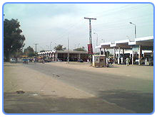
City
 In the past few years, the city has experienced rapid expansion and has become a vibrant economic and cultural center. The old city has fascinating narrow streets and crowded bazaars.
The main market area of the city is centered around "Shandar Chowk", "GTS Chowk", "Muhammadi Chowk" and includes "Main Bazaar", "Niya Bazaar", "Raja Bazaar", "Kinari Bazaar", "Sarafa Bazaar", "Chowk-Ehl-e-Hadith" and Soldier Arcade etc.
Some of the main roads of Jhelum City are Civil Line, Railway Road, Old GT Road, Kucheri Road, Iqbal Road and Rohtas Road.
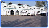
A cantonment was built during the British rule, which has grown up into a strong Garrison, with an Infantry Division commanded by a Major General.
The estimated population of Jhelum in 2009 is 172,073 and the area of Jhelum is about 22 km2 (8.5 sq mi).
Topography
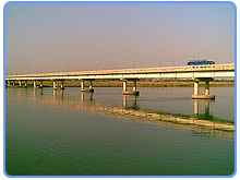
The district capital, Jhelum City, is situated on the right bank of the Jhelum River, crossed by a bridge.
The 16th-century Grand Trunk Road passes through the city. Jhelum city is near the site of the famous
Battle of the Hydaspes between the armies of Alexander the Great and Raja Porus This battle took place a few miles downstream from the city centre, along the river banks. Population of the Jhelum city
(proper) is about 172,073 (2009) and it is the 35th largest city of Pakistan with respect to population. A cantonment was built during the British rule, which has grown up into a strong Garrison, with an Infantry Division commanded by a Major General.
River Jhelum
The river Jhelum is navigable throughout the district, which forms the south-eastern portion of a rugged Himalayan spur, extending between the Indus and Jhelum to the borders of the Sind Sagar Doab. Its cenery is very picturesque, although not of so wild a character as the mountain region of Rawalpindi to the north, and is lighted up in places by smiling patches of cultivated valley. The backbone of the district is formed by the Salt Range, a treble line of parallel hills running in three long forks from east to west throughout its whole breadth.
The range rises in bold precipices, broken by gorges, clothed with brushwood and traversed by streams which are at first pure, but soon become impregnated with the saline matter over which they pass. Between the line of hills lies a picturesque table-land, in which the beautiful little lake of Kallar Kahar nestles amongst the minor ridges. North of the Salt Range, the country extends upwards in an elevated plateau, diversified by countless ravines and fissures, until it loses itself in tangled masses of Rawalpindi mountains. In this rugged tract cultivation is rare and difficult, the soil being choked with saline matter. At the foot of the Salt Range,however, a small strip of level soil lies along the banks of the Jhelum, and is thickly dotted with prosperous villages.
The drainage of the district is determined by a low central watershed running north and south at right angles to the Salt Range. The waters of the western portion find their way into the Sohan, and finally into the Indus; those of the opposite slope collect themselves into small torrents,and empty themselves into the Jhelum.
Agriculture
Jhelum District has a total area of 8,58,767 acres, out of which 3,16,815 acres are cultivated. It has four tehsils viz; Jhelum, Pind Dadan Khan, Dina and Sohawa. The area is located on the eastern part of Potohar upland along with River Jhelum.
Agriculture in the District Jhelum depends mainly on rainfall. The average rainfall of the area varies from 20 to 40 inches. About three fourth of this precipitation is received in monsoon season and the remaining one fourth is received during the rest of the year. The irrigated area at present is limited but the emphasis on construction of small Dams and Mini Dams is gradually increasing. Wheat remains the main crop.
In Tehsil P.D.Khan Salt is the predominant feature which is spoiling the rich agricultural land day by day. There is a long strip of very rich and virgin soil along the river which could be made a paradise of citrus plantation by drip irrigation if the local people are motivated and the Government of Punjab expressed some interest in it.
Flora and Fauna
Vegetation of the forests of Jhelum Forest Division is dry deciduous scrub type, Phulai, Kau and sanatha are the main species. The stocking on the whole is poorand the forests are open. Vegetation is poor on sandstone and redmarl. The southern slopes are often devoid of vegetation while north western slopes carry good forests. The forests of Jhelum Forests Divisions are burdened with right of grazing browsing and firewood. Under settlement out of total area 93,566 acres only 5,468 acres about (45%) are right free. Remaining 55% are open to grazing.
The fauna of the District is mostly indigenous restricted, like the vegetation, but similarly varied and interesting. The rugged and rough terrain,low rainfall, the scantly cover of vegetation and the burning passions of the increasing number of hunters, all have their share in limiting the animal kingdom in the District. The riverine offers a better environment than elsewhere though the hills support a more interesting wildlife. Urial and Chinckara are spot aids while wild bores are found in the Salt Range. Wolves, Foxes and Wild Cats are also found. Hare is fairly common. Chikor grey and black Partridge are also found in the parts of the district. Migratory ducks like Teal Pintail and Mallard and some geese visit during winter.
Find more about Fauna & Flora in Pakistan
Important Sites
 Rohtas Fort is a garrison fort built by the great Afghan king Sher Shah Suri. This fort is about 4 km in circumference and the first example of the successful amalgamation of Pukhtun and Hindu architecture in the sub-continent. Qila Rohtas is situated in a gorge approximately 16 km NW of Jhelum and 7 km from Dina.
The old city has a fascinating labyrinth of narrow streets and crowded bazaars. Opposite to the CMH Jhelum Cantt is located the beautiful mosque of the city, CMH Masjid Jhelum.
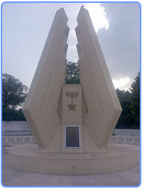
Located in the cantonment area is the St. John's Church Jhelum which was built in 1860. There was a local stadium near Gul Afshan Colony which is now transformed to a Cricket stadium named Zamir Jaffri Cricket Stadium. Close to Zamir Jaffri Cricket Stadium is located the Altaf Park which was constructed in 1994-95. Nearly at a distance of 100m from Shandar Chowk, in the center of city is located Major Akram Shaheed Memorial Park. Major Muhammad Akram Memorial Library is also present in this park. On the 6th of September at the occasion of Defence Day, Parade also took place over here.
 Lehri Nature Park is almost 30 kilometers from Jhelum and 90 kilometres on GT Road in the hilly Pothohar region from Islamabad. It is 10 kilometres from GT Road.
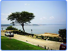
The Mangla Dam is located on the Jhelum River about 30 km (19 mi) from Jhelum, it is the twelfth largest dam in the world. It was constructed in 1967 across the Jhelum River. There is the Mangla View Resort that is the first planned resort development in Pakistan to offer residences, villas, townhouses, hotels, serviced apartments & retail outlets. The resort is located on a 340-acre (1.4 km2) site on the Mangla Dam area.
Rohtas Fort is a garrison fort built by the great Afghan king Sher Shah Suri. This fort is about 4 km in circumference and the first example of the successful amalgamation of Pukhtun and Hindu architecture in the sub-continent. Qila Rohtas is situated in a gorge approximately 16 km NW of Jhelum and 7 km from Dina.The old city has a fascinating labyrinth of narrow streets and crowded bazaars. Opposite to the CMH Jhelum Cantt is located the beautiful mosque of the city, CMH Masjid Jhelum.
Located in the cantonment area is the St. John's Church Jhelum which was built in 1860. There was a local stadium near Gul Afshan Colony which is now transformed to a Cricket stadium named Zamir Jaffri Cricket Stadium. Close to Zamir Jaffri Cricket Stadium is located the Altaf Park which was constructed in 1994-95. Nearly at a distance of 100m from Shandar Chowk, in the center of city is located Major Akram Shaheed Memorial Park. Major Muhammad Akram Memorial Library is also present in this park. On the 6th of September at the occasion of Defence Day, Parade also took place over here.
Lehri Nature Park is almost 30 kilometers from Jhelum and 90 kilometres on GT Road in the hilly Pothohar region from Islamabad. It is 10 kilometres from GT Road.The Mangla Dam is located on the Jhelum River about 30 km (19 mi) from Jhelum, it is the twelfth largest dam in the world. It was constructed in 1967 across the Jhelum River. There is the Mangla View Resort that is the first planned resort development in Pakistan to offer residences, villas, townhouses, hotels, serviced apartments & retail outlets. The resort is located on a 340-acre (1.4 km2) site on the Mangla Dam area.
Transportation
Within city
Auto Rickshaws are very popular mode of transport for short routes within the city. Many of the new rickshaws in the city use Compressed natural gas (CNG) instead of the petrol engines as CNG is environmentally clean and cheaper compared to petrol. Rickshaws by QingQi are another important mode of transportation
Out of City
 There is a regular bus/Hiace service available running from early hours of the morning to late night. Daily routes includes Rawalpindi, Islamabad, Lahore, Gujrat, Gujranwala, Sialkot, Mandi Bahauddin, Sargodha, Chakwal, Mirpur and Faisalabad.
Regular Bus/Van service is also available with in Jhelum District, It include some of the important towns and villages such as: Buses from Jhelum to Pind Dadan Khan, Dina, Sohawa, Lillah, Nakka Khurd, Pind Sawika, Nagyal, Sanghoi, Mangla Cantt, Nara, Domeli, Darapur, Jalalpur Sharif and many more, while Vans from Jhelum to sanghoi, Dina, Kharian, Sarai Alamgir, Chak Jamal. Chak Doulat, Mughalabad, Boken, Dhanyala and many other destinations as well
Railway
 The Jhelum Railway Station was built in 1928 during British rule before the independence of Pakistan. It was connected by the North-Western Railway to other cities in the Indian empire. Jhelum is on main line of Pakistan Railways, and linked to whole country through Railway line across the Pakistan
Air
The nearest airport is the Islamabad International Airport, which is approximately 110 km by road from Jhelum. A small airport called Mangla Airport, located near Dina, is in use of the aviation wing of the Pakistan Army.
Sports
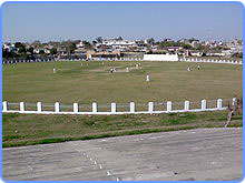 The city also boasts a golf course called the River-View Golf Club, where national golf tournaments are held regularly.
Also there is a Cricket Stadium named Zamir Jaffri Cricket Stadium where District lavel tournaments are held regularly. In October 2008, Pakistan Cricket Board has upraised this stadium for Regional events
There are variety of sports facilities available within the Jhelum Cantonment which include Cricket fields Hockey Fileds, Football fields, Tennis Courts, Squash courts and Swimming Pools.
Some more info about Jhelum
Tehsils & Unions in the District of Jhelum
Tehsil Unions Total Unions
Jhelum BADLOT, BOKEN, CHAK KHASA, CHOTALA, DARAPUR, DHANYALA, DINA-I, DINA-II, GARH MAHAL, JEHLUM-VII, JHELUM-I, JHELUM-II, JHELUM-III, JHELUM-IV, JHELUM-V, JHELUM-VI, KALA GUJRAN, KHUKHA, KOTLA FAQIR, MADU KALAS, MONAN, MUGHALABAD, NAKKA KHURD, NARA., PANDORI, SANGHOI, SOHAN 27
Pind Dadan Khan AHMEDABAD, CHAK SHADI, DAULATPUR, DHARYALA JALAP, GOLEPUR, GUJJAR, HARANPUR, JALALPUR SHARIF, KANDWAL, KHEWRA-I, KHEWRA-II, LILLA, P.D.KHAN, PINDI SAIDPUR, SAUWAL, TOBA 16
Sohawa ADRANA, DOMELI, JAJIAL, KOHALI, LEHRY, NAGIAL, PAIL BANE KHAN, PHULREY SYDAN, PIND MATAY KHAN, SOHAWA 10
Total Number of Tehsils = 3 and Total Unions = 53
_______________________________________________________________
History Jhelum English
Jhelum is known for providing a large number of soldiers to the British and later to the Pakistan armed forces due to which it is also known as city of soldiers or land of martyrs and warriors
Jhelum is one of the oldest districts of Punjab. It was established on 23 March 1849.[14] Jhelum District has a diverse population of 1,103,000 (2006)[15] which mainly consists of Punjabis. The population of the Jhelum city (proper) is about 174,679(2010)[6] and it is the 35th largest city of Pakistan with respect to population. Population Density is 261/km. Population Growth Rate is 1.51[16] which is very low as compared to other urban areas of Pakistan. The majority of the population i.e. 98.47 percent is Muslim. Among the minorities Christians are in majority sharing 1.36 percent in the district. Punjabi is the dominant language (96.6 percent), while, other languages spoken in the district are Urdu (1.9 percent), Pushto (1.2 percent). Major clans are Awans, Akra[disambiguation needed], Bharat, Gakhars, Gujars, Janjua Rajputs, Jalaps, Jats (Cheema, Dhamial Jats, Gondal, Ghuman, Sipra, Nagyal, Thathal, Kashmiris, Khokhars, Lilla Tribe Qureshis, Phaphra Mughals), Rajputs (Bhakral, Bhatti, Chib, Minhas, Narma, Sohlan, etc.), Arain, Syed and Punjabi Shaikh. ( )
Literacy rate of Jhelum is among the highest in Pakistan. At 79%, it is only lower than that of Islamabad and neighbouring Rawalpindi.[17] Somewhat higher than the literacy in Punjab province (58 percent).[17] More History in Jhelum city page JHELUMFB ,The literacy rate has remarkably increased from 38.9 percent in 1981. The rate is much higher in urban area when compared with rural areas both for males and females. 84% of the population have electricity and 96% have the water facility.[18]Human Development Index of Jhelum is 0.770, which highest in Pakistan after Karachi.
Visit Jhelum News Blog
www.JhelumCity.Blogspot.vcom
Dams and barrage
Jhelum River near Bele BBQ
Water control structures are being built as a result of the Indus Basin Project, including the following:
Mangla Dam, completed in 1967, is one of the largest earthfill dams in the world, with a storage capacity of 5.9 million acre-feet (7.3 km³)
Rasul Barrage, constructed in 1967, has a maximum flow of 850,000 ft³/s (24,000 m³/s).
Trimmu Barrage, constructed in 1939 some 90 km from Mari Shah Sakhira town, at the confluence with the Chenab, has maximum discharge capacity of 645,000 ft³/s (18,000 m³/s).
Harahpur (Victoria Bridge) Constructed in 1933 Approximate 5 km from malakwal near Chak nizam Village. Its length is 1 km mainly used by Pakistan Railways but there is a passage for light vehicle (motor cycle, cycle and by boot at both side
Canals:
The Upper Jhelum Canal runs from Mangla Dam to the Chenab.
The Rasul-Qadirabad Link Canal runs from the Rasul Barrage to the Chenab.
The Chashma-Jhelum Link Canal runs from the Chashma Barrage on the Indus River to the Jhelum river downstream of Rasul Barrage. This is 40 km away from
Mari Shah Sakhira town.
Visit Jhelum News Blog
www.JhelumCity.Blogspot.vcom
_
__________________________________________________________
Khewara Salt Mines
Khewra Salt Mines is a salt mine in Pakistan, about 160 kilometers from Islamabad and 260 kilometers from Lahore. It attracts up to 40,000 visitors per year and is the second biggest salt mine in the world. Situated at the foothills of the Salt Range, Khewra Salt Mines are the oldest in the salt mining history of the sub-continent.
Salt has been mined at Khewra since 320 BC, in an underground area of about 110 sq. km. Khewra salt mine has proven reserves of 300 million tons. This reserve could not be consumed in 600 years even at the rate of 5 lakh tons production every day. Current production from the mine is around 3 lakh tons.
The mine-head buildings have 17 storeys, with 11 below ground. The salt-mine is 945 feet above sea level and extends around 2,400 feet inside the earth from the mine-mouth. There are 17 working levels and the cumulative length of all tunnels is more than 40 km.
Salt occurs in the form of an irregular dome like structure. There are seven thick salt seams with a cumulative thickness of about 150 meters. At places the rock salt is 99% pure. Salt is transparent, white, pink, reddish to beef-color red. There are beautiful alternate bands of red and white color salt
By :Waqas Mehmood
Published 24/9/2011
Special Thanks To:
:S.A.K
:Mirza Baig
:Guriya
:Kamran Chughtai
:Unique Acadmy (jada)
:Tahir Madical Store (Karim Pur,jhelum)
:Like our facebook Page I Love Jhelum City
"Thank You"
Published 24/9/2011
Special Thanks To:
:S.A.K
:Mirza Baig
:Guriya
:Kamran Chughtai
:Unique Acadmy (jada)
:Tahir Madical Store (Karim Pur,jhelum)
:Like our facebook Page I Love Jhelum City
"Thank You"
History of Masjid.e.Afghaan Jhelum?
ReplyDeleteHistory of Masjid.e.Afghaan Jhelum?
ReplyDeleteThis comment has been removed by the author.
ReplyDeleteWow , great urdu blog , please also add more information in this blog , i really like it ,
ReplyDeleteyellow pages spider
Masha Allah commendable History.
ReplyDeleteI also belongs to Distt Jhelum which is known as soldiers city.
Like my self a soldier of Pakistan Air Force.
(Ret,w/o JAVED Iqbal Commando)
Harrah's Cherokee Casino Resort & Spa Opening on
ReplyDeleteThe property 영천 출장안마 was renamed Harrah's 서울특별 출장샵 Cherokee 파주 출장샵 Casino on Monday, June 3, as the resort announced plans 태백 출장안마 for a massive expansion of 동해 출장샵 the
Best eCOGRA Sportsbook Review & Welcome Bonus 2021 - CA
ReplyDeleteLooking for https://deccasino.com/review/merit-casino/ an 1xbet 먹튀 eCOGRA Sportsbook poormansguidetocasinogambling.com Bonus? At this eCOGRA Sportsbook review, we're talking about a variety of ECCOGRA https://jancasino.com/review/merit-casino/ sportsbook promotions.